PixGPS - Geotag your digital photos
 Have you ever wanted to know the exact position of where your digital photos were taken?
PixGPS is a simple program for Microsoft Windows that makes it simple to insert the exact position of each photo (latitude and longitude) into the photos EXIF meta data.
All you need is:
- a digital camera that stores EXIF inside the image file (most cameras do this)
- a GPS Receiver that can store track logs in GPX format.
- the PixGPS software.
Download a free trial today!
Buy PixGPS now!
It's simple!
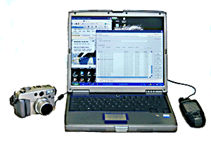
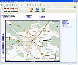
PixGPS makes it easy to geotag your digital photos. Just download the photos from your camera and get the GPX formatted track log from your GPS Receiver. The PixGPS Geotagger will in matter of seconds calculate the latitude and longitude for each of the photos. It will store the latitude and longitude in each photos EXIF meta data so it will stay with the photo. You can later use other software with EXIF GPS support to view the exact location of the photo, or you can use whe simple 'View on map' function in PixGPS to view the location in Google Maps or MapQuest (requires an Internet connection).
Who needs Geotagging?
 For many of us, geotagging the digital photos are really useful. Of course it depends on what kind of photos you take, but if you take photos when travelling, it can be useful to see where you took photos on this trip. Let's say you take photos in a city. Will you remember were you took the photo of that building? PixGPS Geotagger can tag the photos location within 10 meters/30 ft. *)
For businesses that uses photography to document their work, storing the exact latitude and longitude in the photos EXIF meta data can be essential for future documentation.
*) The actual accuracy may vary depending on your GPS receiver and the GPS signal reception at the location.